Interview at BAKOSURTANAL, Indonesia
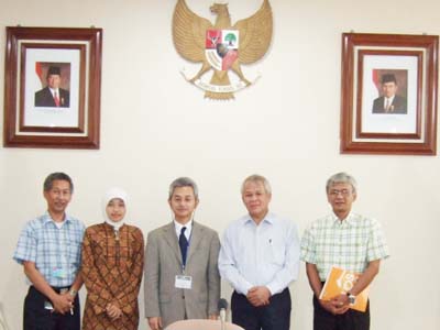
APRSAF secretariat visited to BAKOSURTANAL's office in Cibinong. Name of Person (from left to right): Dr. Ir. Poentodewo SSO, M.Surv.Sc (Head of Center for Topographic Base Mapping and Spatial Planning/PDRTR), Elyta Widyaningrum, ST (Staff of PDRTR), Mr. Kyoichi Ito (APRSAF Secretary), Ir. Rudolf W. Matindas, M.Sc (Chairman of BAKOSURTANAL), Ir. Bebas Purnawan, M.Sc (Head of Centre for Network System and Spatial Data Standardization).
History of Bakosurtanal
The National Coordinating Agency for Surveys and Mapping (BAKOSURTANAL) was founded on October 17th, 1969. Then in 1998, this Presidential Decree was renewed with the Presidential Decree of the Republic of Indonesia number 87/1998. According to this new decree, BAKOSURTANAL had a duty to assist the President in the development, management, maintenance and coordination of surveys and mapping and also the maintenance of the national geographic data and information according to prevailing regulation.
In implementing its duties, BAKOSURTANAL executes some functions: To asses and create national policies in surveys and mapping; To develop a national spatial data infrastructure (NSDI); To coordinate functional activities in conducting BAKOSURTANAL tasks; To monitor, guide and maintain activities of government institutions in the field of national surveys and mapping; and To organize, develop and serve in the field of general planning, management, organization, personnel, financial, archive, regulation, code and internal affair. In executing its function, BAKOSURTANAL has the authority To formulate a national plan for surveys and mapping; To formulate surveys and mapping policies to support macro development; To determine information system in its field; To conduct other authorities that are related and implemented according to prevailing regulation.
Vision of BAKOSURTANAL is to implement a reliable spatial information system through development of national spatial data infrastructure.
And BAKOSURTANAL's mission is to arrange macro planning, to formulate national policies in the field of surveys and mapping and improve national coordination for surveys and mapping activity to fulfill base map requirements for national area coverage used for national development; and to develop national spatial data Infrastructure including: institution, regulation, spatial fundamental data, human resources, research and development of surveys and mapping and to improve public services of spatial information.
Remote Sensing and Bakosurtanal
To ensure its visions and missions, BAKOSURTANAL as a governmental body in the field of surveys and mapping have set goals, which are: Fulfillment of base maps up to medium scale for national and regional purposes; Fulfillment of national thematic base maps in supporting governmental tasks and development activities for regional development; and Fulfillment of the policy assessment, model enhancement, system or guidelines for the development of national spatial data infrastructure which cover elements of institution, regulation, spatial fundamental data, human resources, research and development of survey and mapping and management of spatial information services to public.
Current Activities of BAKOSURTANAL which is utilizing Remotely Sensing Data is implementing Airborne Interferometry Synthetic Aperture Radar (IFSAR) for Topographic Mapping in Kalimantan, Sulawesi, Central Sumatra, and Buru Island for Base map production with scale 1:50.000 and 1:25.000, Analogue Aerial Photograph for Mapping in Kalimantan in 1:50.000 scale and Digital Aerial Camera for Aceh mapping with scale 1:10.000 dan 1:5000. We are also using remote sensing data for our Digital Marine Resource Mapping project, Indonesian Atlas and Earth Observation activities.
In the future, we will complete the development Indonesian Spatial Data Infrastructure, to fill gap and to update our national-wide fundamental geospatial dataset, with recent technology optimally and available in market.
Role of BAKOSURTANAL in Disaster Management
Based on its competency, BAKOSURTANAL had took its responsibility in documenting data for surveys and mapping such as terrestrial photos, high resolution satellite imagery, maps, geographical names. BAKOSURTANAL had also done GPS measurement in hundreds of pillars along West Coast of Sumatra.
The foreign aids in Mapping production to support rehabilitation and reconstruction (post disaster) tsunami and earthquake of Nanggroe Aceh Darussalam such as Norwegian, Japan, France and Australia have implemented, which coordinated by BAKOSURTANAL.
- Norwegian activity : Digital Aerial Photography and mapping production 1:10.000 and 1:5000
- Japan activity : Digital Maps 1:2000 by utilizing digital aerial photo produced by Norwegian
- France activity : Travel maps and Odonimy scale 1:10.000 by utilizing digital aerial photo produced by Norwegian
- Australian activity : Digital maps 1:10.000 using IFSAR
Its aim is to remap Nanggroe Aceh Darussalam (Aceh) Province after the disaster that had changed its landscape. Those activities are aimed to support evacuation, rehabilitation and reconstruction of Indonesia Government along with other countries, private sectors, non-governmental organization (NGO) and the world organizations for humanity. BAKOSURTANAL is in cooperation with various country for accessing Disaster Assessment and Geospatial Information derived from remotely sensing data for Aceh Rehabilitation and Reconstruction activities and the other activity to support TEWS (Tsunami Early Warning System) with Germany, Japan, USA, etc.
In the future, with appropriate remotely sensing data, we would like to build disaster proneness map and to monitor earth that causing disaster so we can develop Multi Hazard Disaster Early Warning System.
Future Plan
- Multi Hazard Disaster Early Warning System
- National Spatial Data Infrastructure, including: Fundamental Dataset(Gap filling, updating), Spatial Data Standardization(Integration and Interoperability), Capacity Building, Policy and Technology.
International Cooperation
- UNGEGN (United Nation Group of Expert on Geographical Names)
- PCGIAP (Permanent Committee on GIS Infrastructure for Asia Pacific)
- FIG (International Federation of Surveyors)
- IAG (International Association of Geodesy)
- UNESCAP (United Nations Economic and Social Commission for Asia Pacific)
- ASEAN FLAG (ASEAN Federation of Land Surveying and Geomatics)
- GSDI (Global Spatial Data Infrastructure)
- ISPRS (International Society for Photogrammetry and Remote Sensing)
- IHO (International Hydrographic Organization)
- ICA (International Cartographic Association)
- International Global Mapping Project