Introduction to RazakSAT (Malaysia's remote sensing satellite)
This article was written in collaboration with the Astronautic Technology (M) Sdn Bhd (Dr. Tuan Hj Norhizam Hamzah and Dr. Rosymah) and APRSAF secretariat.
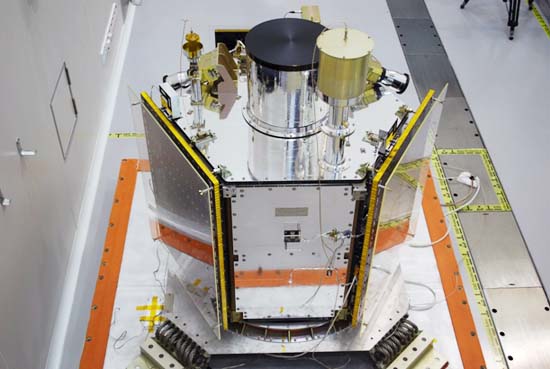
RazakSAT (Fig. 1) is scheduled to be launched from Kwajalein Atoll, an island located in the Republic of the Marshall Islands, U.S.A. on July 14, 2009 using a Falcon 1 launcher developed by SpaceX. RazakSAT is a small Low Equatorial Orbit (LEO) satellite that carries the electro-optical payload of a Medium-sized Aperture Camera (MAC) - a pushbroom camera with 5 linear detectors (1 panchromatic, 4 multi-spectral).
RazakSAT was named after the second prime minister of Malaysia, Tun Abdul Razak (known as the Father of Malaysian Development) a moniker given to him by the former prime minister of Malaysia, Tun Mahathir Mohamad.
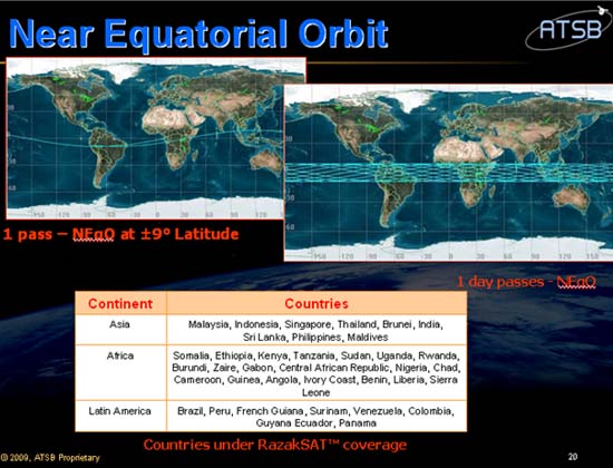
In order to acquire the most number of images for Malaysia and other countries in the equatorial belt (Table 1), the satellite will be launched in Near Equatorial Orbit (NEqO) with an inclination of 9属 (Fig. 2) and will have up to six opportunities a day to take images and overcome the major obstacle to passive remote sensing, namely, cloud cover. Another requirement for most remote sensing applications is access to high spatial resolution data. Driven by these requirements, the mission of RazakSAT is to provide a satellite with high re-visits and high-resolution data.
The specifications of RazakSAT are shown in Table 2.
To handle mission operations, there will be a new ground station in Sg. Lang, Banting under the control of the Malaysian National Space Agency (ANGKASA) and it will consists of a Mission Control Station (MCS) and an Image Receiving and Processing Station (IRPS). MCS will perform mission planning, command generation, telemetry reception, archiving and analysis. IRPS will archive images together with data on attitude and ephemeris telemetry for post-processing and distribution.
The images and data from RazakSAT will be received and distributed by the Malaysian Remote Sensing Agency (ARSM) ground station located in Temerloh, Pahang. In addition, other ground stations located in the NEqO will also be able to receive the images.
Copyright ATSB
Fig. 1 RazakSAT
Copyright ATSB
Fig. 2 Near Equatorial Orbit
Table 1 List of Countries Covered by NEqO (9o inclination)
| Continent | Countries |
|---|---|
| Asia | India, Indonesia, Malaysia, Maldives, Philippines, Sri Lanka, Thailand |
| Africa | Angola, Benin, Burundi, Cameroon, Central African Republic, Chad, Cote d'Ivoire, Ethiopia, Gabon, Guinea, Kenya, Liberia, Nigeria, Rwanda, Sierra Leone, Somalia, Sudan, Tanzania, Uganda, Zaire |
| Latin America | Brazil, Colombia, Ecuador, French Guiana, Guyana, Panama, Peru, Surinam, Venezuela |
Copyright ATSB
Table 2 Key Technical Features of RazakSAT
| Subsystems | Key Features |
|---|---|
| Orbit | 685 km Near Equatorial |
| Inclination | 9 degrees |
| Payload (MAC) | GSD: 2.5 m (PAN), 5 m (MS) Swathwidth: 20 km |
| Electrical Power Subsystem (EPS) |
GaAs/Ge solar cells on honeycomb substrate NiCd batteries (18 Ahr) Constant current control Solar Power: 330 W @ EOL |
| Command and Data Handling Subsystem (C&DH) | Two on-board computers Telemetry and command interface modules Analog Telemetry channels: up to 90 Digital Telemetry channels: up to 120 |
| Telecommunication Subsystem (TS) | 9600 bps/1200 bps S-band TT&C uplink 38.4 kbps/9600 bps/1200 bps S-band TT&C downlink |
| Payload Data Management | 32 Gbits On-board solid-state memory 30 Mbps X-band payload data downlink |
| Structure and Thermal Control | F1200 ' 1200 mm Hexagonal shape Mass: less than 200 kg Modular structure Passive and Active thermal control |
| Mission Life | 3 years |
Copyright ATSB